
I’m in this picture, and I don’t like it
I don’t think I am - and I do like it.
How’s that 8-day trip to ISS going?
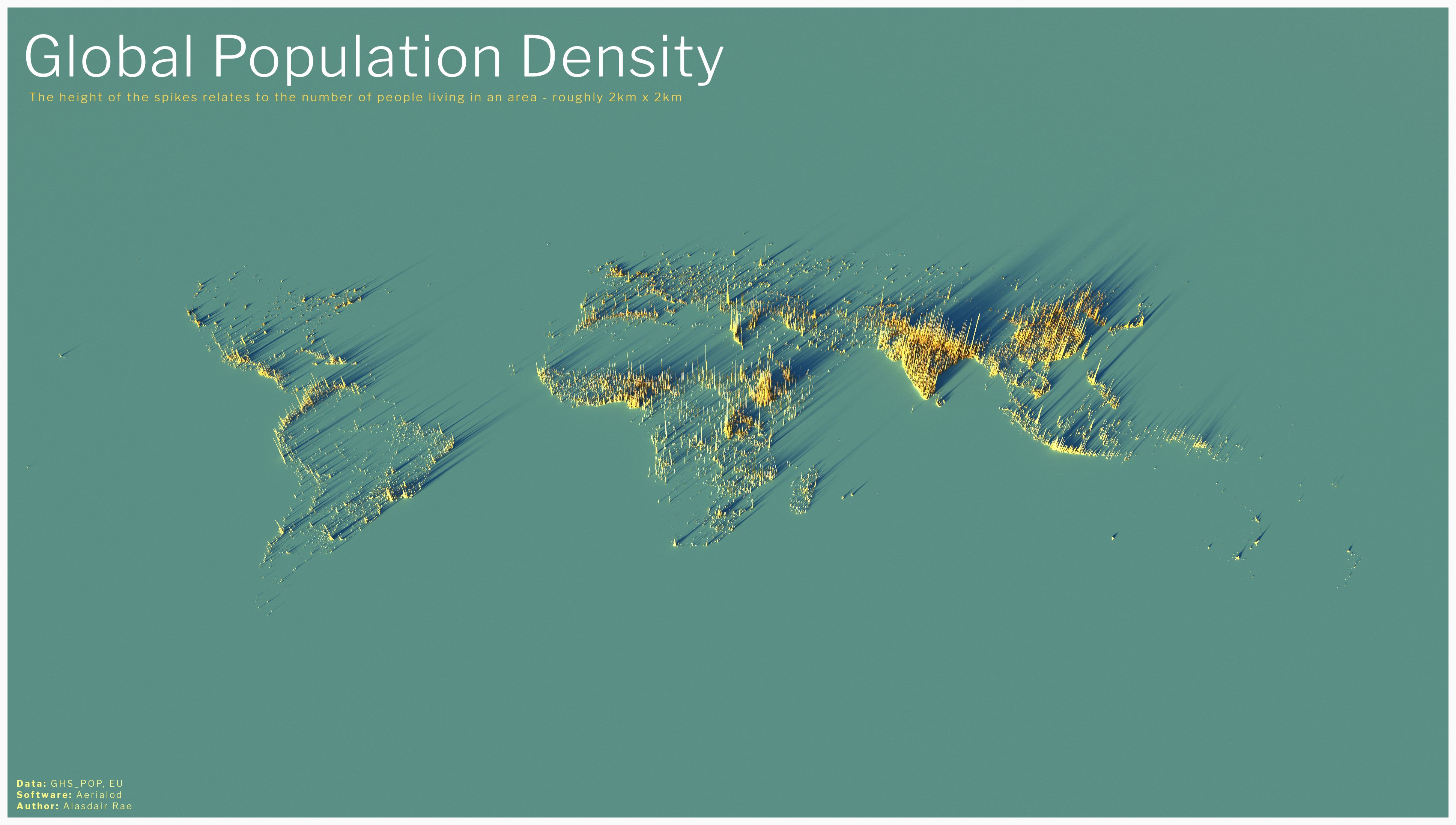
Nothing that exciting. I just live in a very small community, quite a distance from any larger community, and I’m pretty sure that at the scale of that map - my community doesn’t exist. If I zoom in enough, maybe there’s something there, but I think it’s digital compression artefacts.
Dang, India needs to find a different hobby.
Imagine what if it would be an Olympic sport? They’d probably take the gold if my ex wouldn’t be competing.
Yet other map ignoring New Zealand.
/s
I get your joke but isn’t it there? Or is this part of Austria? It’s hard to tell but I think New Zealand is there
It’s there. I’d argue Australia is worse off in this map.
Yet it is there. Only continent totally thrown of the edge is Antarctica. I wonder why… just asking questions, not implying any agenda
I don’t think penguins are included in the population count, otherwise NZ would have another 500k population.
I’m pretty sure there’s a Big Antarctica conspiracy to keep penguins off the map, hiding their army of 44m penguins.
Beautiful map!
This place acts like legends are illegal or something.
This map looks good, but feels somewhat misleading. For me, it looks like India is home to about half of the world’s population.
Still, very beautiful presentation.
India has 17% of the world’s population - on a scale like this image, that’s not far off “about half”! It looks right to me.
Ray Tracing to make the data science look good.
👍
Holy shit i had no idea Ethiopia was so crowded. it’s cool how you can see population swells around the Nile and Lake Victoria too. and the Mediterranean coast of course. and I guess Nigeria is just a good place to live??
The Sahara looks pretty hostile here
Huh, I can read Canada. I call bullshit on the 2x2 thing, though. This is more like 10x10, otherwise you’d see a lot of smaller communities.
It’s mostly not surprising, but laid out like that I wonder how long places out of the historical spotlight have been that populous. Ethiopia is quasi-historical enough we can be pretty sure it’s long been a center, but the African Great Lakes? Who knows.
What was it?
c/mapswithoutnewzealand
Madrid is gone, reduced to ashes? And so is Barcelona? Weird
They are there but hidden beyond North Africa spikes
Pretty sure that if you can see Valencia and surroundings, you should be able to see Barcelona which is to its northeast, and that small central peak in the Iberian Peninsula looks to me to be close to Madrid, what is it then?
I’m on mobile, so a bit annoying to edit pictures, but having looked at it again, Barcelona and Madrid are visible.


