
Eh, close enough.
If you had to condense it for a videogame, this would cover most bases.
Los Santos, Liberty City, Vice City.
And the big empty bit in the middle to hide the loading.
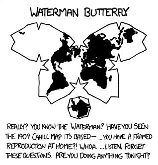
I don’t get this though. Maps are free online. You don’t even have to guess anymore.
Exactly. Maps are free. Joke maps are also free. So instead of paying money, and somebody taking that money and assuring you this is the right thing. You get a free map, that might be a joke, but you don’t know it’s a joke cuz you don’t know the map. And we get some funnies
Where do they take maps from? 9gag? I mean, maps.google.com is free. It can’t be any easier.
I mean 9gag stands for 9 Good American Guys right? What better place to get your accurate American maps from?
Google images most likely
Yes, I’m sure using Google content on your commercial news channel is simple as can be.
You don’t have to use their content, but you can double-check that your map is correct, mister sarcasm.
deleted by creator
I’m guessing this was an in-the-nutshell style meme, and they just didn’t know enough to sense the ironic oversimplification.
A bit like a map on how Europe is perceived by Americans, where whole Germany is Bavaria.
If you had to divide the mainland US into 4 “regions” this is probably the best way to split it.
I contest this by pointing out that Arizona is basically the grumpy younger sibling of California and is not allowed to hang out with Texas.
the four corners states all going to go live with the pacific side of the family except for Utah who thinks the devil’s lettuce has corrupted them all
Yeah, we also dont really want Utah cause well who does. The US could collapse into a warlord era and Utah would at best be turned into a Neutral we dont want it ground.
Was this a news report from the future on the signing of the Treaty of 2034 that ended the second US Civil War?
How dare you split Michigan logically!
Can you explain to the non-US citizen the split in Michigan? If you want I can explain the split in Lorraine, France in exchange (^_^)
The state of Michigan exists on both sides of the great lakes (which are effectively freshwater oceans, containing their own maritime economies, marine salvage operations, maritime weather and even famous lost ships) so there’s the Michigan mainland which contains major cities like Detroit, Lansing, Ann Arbor and Grand Rapids, but then there’s the “upper penninsula” which is heavily wooded and some consider a continuation of the “north woods” of Wisconsin. Map for context:
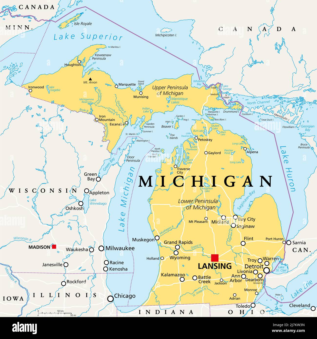
Thanks.
As promise, here is the explanation for the split in Lorraine: Lorraine is a region in easter France that is culturally split in two. One part is of Frank culture, like Paris and French tradition, the other as a culture much closer to Germany, Luxembourg and german speaking countries. It also as a germanic tradition as local languages used to be some german dialect rather that french dialect.
This part of Lorraine which is roughly the Moselle county used to be called germanic Lorraine but this term started to be ambiguous when France lost Alsace, the very famously german-cultured region at the border of France and Germany, and the Moselle county in 1871.
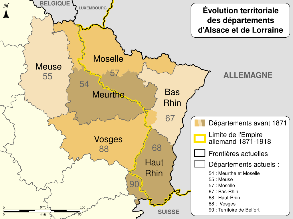
After the great war, Alsace-Moselle was part of France again, but as some of its social laws where better than France at the time, it was decided to keep them in place and not to apply the laws that where voted in France when it was part of German. Because of that, today Lorraine is separated not only culturally but also by laws in place. Go to Metz, on the germanic part, and have two more non-work holiday as in Nancy in the french. In Nancy and Metz, social contributions are calculated differently and important laws for France are not applied no the german side : Church and State are not separated there.
Of course, French State work on every day following that law but in Moselle and Alsace, men of worship can be pay with public money.
All that with having Nancy and Metz separated by 50 km and both being part of Lorraine.neat, thanks!
I know I don’t live in Texas because we still have electricity running here. Florida checks out though!
I like how the New York, Florida, and Texas tristate border still makes my homeland of western Kentucky instantly recognizable by the weird little nubbin that is the Jackson Purchase.
Same with the harsh 90* angle in the CA/TX border. That’s Utah, baby! 😎
This is what those “state vs state battle royale” fantasy war simulators look like after a couple rounds
ඩ
It certainly feels that way sometimes.
looks about right…
Wait a minute, this isn’t !cartographyanarchy@lemm.ee!
Crossposted!


